 |
Mayfields of South Carolina
|
|
|
|
|
Pendleton County, South CarolinaAn Essay by Phil Norfleet
Pendleton County was formed six years after the close of the Revolutionary War, in 1789. The county was formed out of land that had been conquered from the Cherokee Nation in 1776 but which had remained largely unsettled until 1783. By the year 1790, the time of the first Federal Census, Pendleton was the principal frontier area of South Carolina (SC) and was the main SC gateway to what remained of Cherokee territory.
Pendleton County Chronology
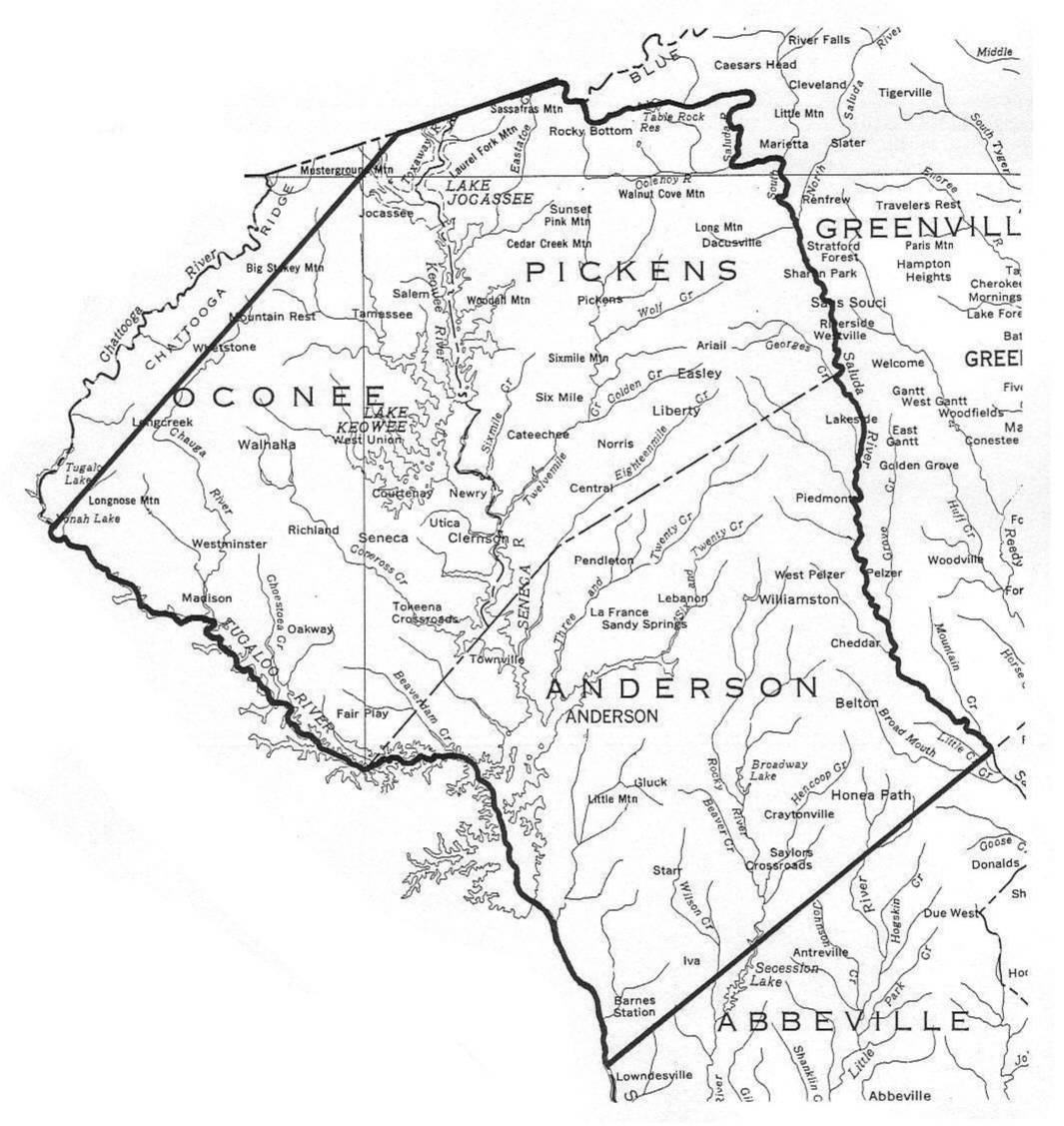
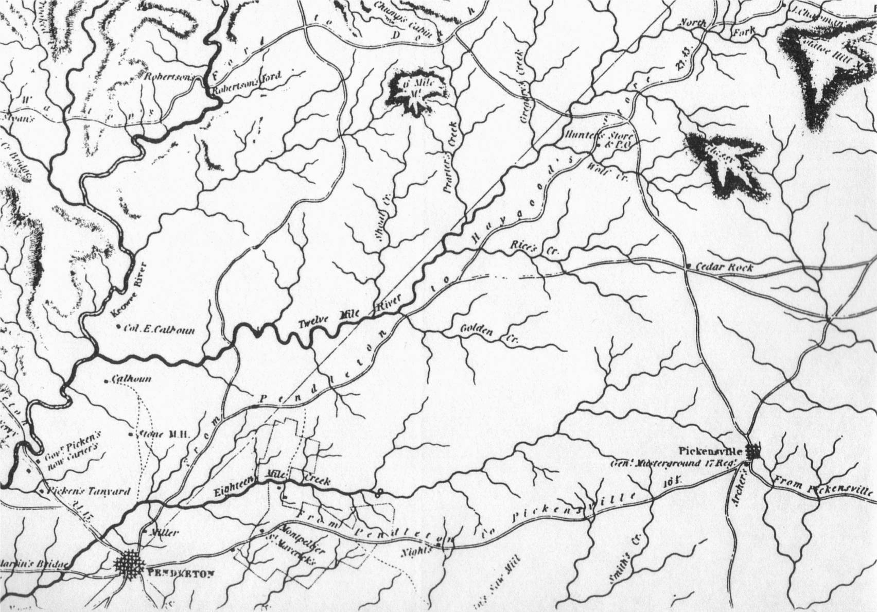
Mayfields in the Pendleton County SC Land, Court & Census RecordsMy research, conducted at the South Carolina State Archives in April 1999, disclosed many early court and land records pertaining to Mayfields living in the Pendleton area, starting in 1785, four years before the county was created. The early Mayfield settlers in the Pendleton area all settled along tributaries of Twelve Mile River, viz., Goldens Creek, Rices Creek and Wolf Creek. The map shown below illustrates this area.
The following is a chronological abstract of these court and land records for the years 1785-1820: 6 April 1785: A 240-acre tract of land on Goldens Creek, a tributary of 12 Mile River, in what would, in 1789, become Pendleton County, is surveyed and certified for Elijah Mayfield. [See SC Plat Book 17, page 113]5 February 1787: Elijah Mayfield receives the grant for the 240-acre tract surveyed for him in 1785. [See SC State Grant Book 17, page 613] 10 May 1790: Stephen Mayfield, et al. came into Pendleton County Court and acknowledged a bond to the county in the amount 100 pounds in connection with Stephen's obligation to " ... sufficiently and carefully provide for his infant bastard child by Catherine Briant and shall till the said child shall attain the age of ten years, so that it shall not [be] in any manner burdensome or chargeable to the County ... " [See Pendleton County Court Minutes, page 24] 15 July 1791: A 428-acre tract of land situated on Goldens Creek, a tributary of 12 Mile River, is surveyed for Isaac Mayfield. The same survey document indicates that the land was certified to him on 15 December 1791. The plat map associated with the survey document indicates that Isaac's land is directly adjacent to land surveyed for Elijah Mayfield. [See SC Plat Book 27, page 563] 27 July 1791: A 338-acre tract of land situated on Goldens Creek, a tributary of 12 Mile River, is surveyed for David Hamilton. The same survey document indicates that the land was certified to him on 3 December 1792. The associated plat map indicates that David's land was directly adjacent to land surveyed for John Mayfield (see below). [See SC State Plat Book 31, page 145] 12 October 1791: A 303-acre tract of land situated on Goldens Creek, a tributary of 12 Mile River, is surveyed for John Mayfield. The same survey document indicates that this land was certified to him on 14 December 1792. The associated plat map indicates that John's land was directly adjacent to land surveyed for David Hamilton. [See SC Plat Book 29, page 377] 25 October 1791: Ambrose Mayfield surveys a 45-acre tract of land on Goldens Creek, a tributary of 12 Mile River. However, the same survey document indicates that this land was subsequently certified to Robert Waring, on 20 July 1793. The plat map associated with this survey document indicates that Ambrose's land was directly adjacent to land previously surveyed for David Hamilton. [See SC Plat Book 31, page 301] 02 January 1792: Isaac Mayfield receives the grant for the 428-acre tract of land surveyed for him in 1791. [See SC Grant Book 29, page 318] 10 March 1792: A 260-acre tract of land situated on Rices Creek, a tributary of 12 Mile River, is surveyed for Stephen Mayfield. The same survey document indicates that the land was certified to Stephen on 27 November 1793. The associated plat map indicates that Stephen's land was directly adjacent to land previously surveyed for Isaac Mayfield. [See SC Plat Book 29, page 376] 13 October 1792: Elijah Mayfield conveys his 240-acre tract on Goldens Creek to James Brown. [See Pendleton County Deed Book C-D, pages 375-376] 07 January 1793: John Mayfield receives the grant for the 303-acre tract of land he had surveyed in 1791. [See SC State Grant Book 31, page 460] 02 December 1793: Stephen Mayfield receives the grant for the 260-acre tract he had surveyed in 1792. [See SC State Grant Book 36, page 26] 15 January 1794: Isaac Mayfield conveys his 428-acre tract of land on Goldens Creek to James Brown. [See Deed Book C-D, page 376] 5 November 1795: Elijah Mayfield acquires a 158-acre tract of land on 12 Mile River from John Patterson. [See Deed Book C-D, page 353] 27 September 1797: Elijah and wife, Elizabeth Mayfield, convey the above cited 158-acre tract to George Miller. [See Deed Book C-D, pages 353-354] 12 April 1799: Elijah and Elizabeth Mayfield convey a 270-acre tract on 12 Mile River to Bennet Combs. Witnesses to the transaction are Stephen Mayfield and Isham Mayfield. [See Deed Book E, pages 22-23] I could find no documentation in the county records as to how Elijah obtained title to this land. 10 January 1801: Elijah Mayfield and Elizabeth, his wife, convey a 260-acre tract on Rice's Creek of 12 Mile River to Edwin Bain. This was land that had been " ... granted to Stephen Mayfield the 19th day of February 1791 [sic] ... ." [This stated date of Stephen Mayfield's grant is wrong - it should be 02 December 1793!] The deed was recorded in Pendleton District on 11 March 1801. [See Deed Book F, pages 150-151] It should be noted that this deed is unreadable on the microfilm. I visited the SC State Archives at Columbia in July 2000 and reviewed the original Deed Book F. The ink is badly faded with respect to this indenture but is still readable. 25 March 1801: Austin Mayfield witnesses the sale of a slave from Perin Faro to James Parkador. The deed of sale was recorded in 1801. [See Deed Book F, pages 314-316] 02 February 1805: Samuel and Jenny McCully convey a 327-acre tract of land situated on Rocky River, a tributary of Savannah River, to Sugar Mayfield. One of the witnesses to this transaction is Abraham Mayfield. [See Deed Book H, pages 448-449] 29 March 1808: John Mayfield conveys a 100-acre tract of land, situated on Goldens Creek, to William Mayfield. [See Deed Book I, page 174] 29 December 1808: Edward Grahm conveys a 500-acre tract of land on Hen Coop Creek to Abraham Mayfield. [See Deed Book I, page 317] 29 March 1809: Edmond Mayfield conveys a 300-acre tract of land, situated on Conneross Creek, to James Kilpatrick. [See deed Book I, page 416] 01 October 1810: Sugar Mayfield conveys a 327-acre tract of land, situated on the waters of Rocky River, to John McFall. [See Deed Book K, page 241] 29 March 1814: Abraham Mayfield conveys a 83-acre tract of land, situated on waters of Cherokee Creek, to Ephriam Mayfield. [See Deed Book M, page 239] 24 October 1815: James Brown (by Sheriff) conveys to Austin Mayfield a 107-acre tract of land on Hen Coop Creek. [See Deed Book M, page 426] 24 October 1815: Brittian Griffin conveys a 117-acre tract of land, situated on Cherokee Creek, to Austin Mayfield. [See Deed Book M, page 425] 24 October 1814: William Taylor conveys a 100-acre tract of land on Hen Coop Creek to Austin Mayfield. [See Deed Book M, page 426] 24 October 1815: Patrick Norris (by Sheriff) conveys a 107-acre tract of land on Hen Coop Creek to Austin Mayfield. [See Deed Book M, page 426] 02 February 1818: William Mayfield conveys a 112-acre tract on the waters of Goldens Creek, to Josiah Prayton. [See Deed Book O, page 53] Table - Mayfields in the 1790 Census for Pendleton
Analysis of the Mayfield Census, Court and Land RecordsSix Mayfield households/families are identified in the 1790 Federal Census for Pendleton. In the 1790 Report the last names of all six are mispelled - "Mafield" instead of Mayfield. A comparison of the 1790 Census with the 1800 Census for Pendleton County indicates that two of the Mayfields listed in 1790 had moved out of the county by the time of the 1800 Census, i. e., Stephen and Isham Mayfield. Review of the land records cited in the above Chronology clearly show at least four of the six Mayfields included in the census lived on land that was either directly adjacent to or very near to each other. Based on the location descriptions contained in the land surveys, all of the Mayfields lived on tributaries of 12 Mile River; all except Stephen, lived on Goldens Creek. Both John and Ambrose Mayfield's land tracts were directly adjacent to that of a certain David Hamilton. Only Isham and one of the two John Mayfields listed in the 1790 Census do not seem to have had their own land. By 1791, another Mayfield not listed in the Census, Isaac, had moved into the area and settled on a tract of land adjacent to that of Elijah Mayfield; Isaac apparently did not stay long for he sold his 428-acre tract of land to a certain James Brown in 1794; Isaac does not appear in any of the Pendleton records thereafter. James Brown had previously acquired (in 1792) the 240-acre tract of land granted to Elijah Mayfield in 1787. Some sources have indicated that this James Brown was a former Tory who had been expelled from Georgia after the Revolution and had sought refuge in the then unsettled area of SC which later became Pendleton County. At least one historian has asserted that about 16% of the early settlers in the Pendleton area were former Tories fleeing from banishment edicts and estate confiscation in Georgia. [See Frederick Van Clayton, The Settlement of Pendleton District 1777-1800, page 24] It is probable that all seven of the Mayfields, shown in the 1790 Census for Pendleton County SC, were closely related to one another. My thoughts concerning these individuals are presented in the following table:
|